

Get to know Chapada Diamantina
Besides housing and impressive chain of mountains that works as a natural reserve, full of rivers, caves, canyons, waterfalls, rare specimens of plants and lots of animals, Chapada Diamantina National Park is the ideal option for people who practice ecotourism but also for those who never had a closer contact with nature.
Nowadays, living on a constant state of stress and anxiety, it´s proven that the contact with natural environments improves our health and mood, it gives us more energy, rests our mind and promotes wellbeing for body and soul!
When you practice Ecotourism, you help protecting the Nature and the communities involved, having the opportunity of making your trip with a win-win-win relation.
By choosing well your route and treading the paths of Chapada always accompanied by professionals that follow the principles of ecotourism, that knows the routes and evaluate the risks of every activity to provide a truly safe adventure, we guarantee that it will be one of the best trips of your life.
Travel to the Nature is to give yourself a gift with benefits that will last forever.
Chapada Diamantina is the perfect place to meet indescribable natural beauties with all the comfort and structure that you need when you are on vacation.
Try it!
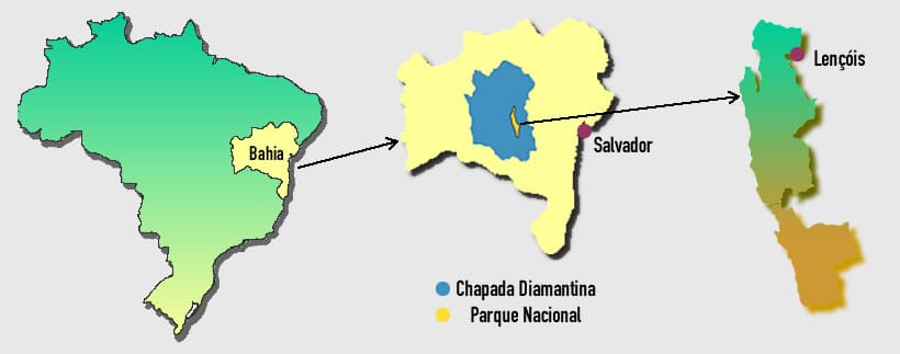
Chapada Diamantina is located on the center of Bahia state (one of the main states of the Brazilian northeast region), 420km from the capital Salvador. It is a wide area of 38.000 km² over an extensive plateau that varies from 400m to 2000m above the sea level. The area is bigger than a lot of countries such as Netherlands, Belgium or Israel.
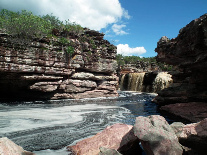
Its formation process began around one billion and six hundred million years ago and today it´s possible to appreciate the result of the erosion caused by the winds, rivers and seas on the many layers of sedimentary rocks of the region.
The creation and occupation of the Chapada Diamantina´s cities and villages is a direct result from the diamond exploration. On the XVIII century began the gold mining on the south part of Chapada, on the region of Rio de Contas. But it was the discovery of diamonds on Serra do Sincorá, on the XIX century, that started the forming the future cities of Mucugê, Andaraí and Lençóis, which became the center for the diamond commerce at the time. The money flow attracted people from all places, adventurers, country people, miners, slave owners, merchants and many others.
After around twenty-five years, duration of the main phase of mining, started the decadence of the diamond on the region and discovery of new diamond deposits in Africa. The region was abandoned and those who stayed adapted to the rural work, cattle and agriculture. In areas with less prosperous soil, such as Lençóis, the mining lasted until around 1985, when the activity was finally prohibited, and the National Park was created with the intention of protecting the region and encouraging the ecological tourism.
The park has a total area of 1520km², with more than half on Serra do Sincorá, surrounded by the main cities and villages of the region: Lençóis, Andaraí, Mucugê, Palmeiras, Vale do Capão and Igatu.
Nowadays, thousands of tourists from all over the world visit Chapada Diamantina every year, enjoying amazing sights of waterfalls, mountain chains and impressive canyons, natural pools with turquoise colored water, a complex of limestone caverns and even wetlands are some of the many attractions of the region.
Nature
The vegetation of Chapada Diamantina is diverse, mixing areas of rainforest, rocky fields, agrestes and caatinga, comprising diverse species of orchids, bromeliads, climbing plants, besides a great variety of medicinal plants.
Amongst the animals found on the region, stands out the variety of birds and reptiles, animals like the anteater, armadillo, porcupine, wild cats, capybara and others. Some species are threatened with extinction, mainly due to hunting.


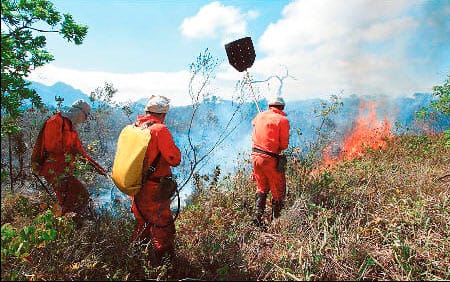
The fire
The fire today is Chapada´s biggest enemy. Every year the region suffers with criminal forest fire, mainly on the dry season when the heat, the dry vegetation and the wind spread the flames very quickly, affection regions of native vegetation and water springs.
The government resources are minimum towards the region´s needs and all the forest fire fighting is made by volunteer brigades formed by guides, natives, residents and nature lovers from each part of Chapada who risk their lives to protect the beauties of the region they live in.
Sources:
- A Guide to Chapada Diamantina, Roy Funch
- Adaptation from the book “Protection Inventory of Cultural Heritage, Monuments and Sites Protection from Serra Geral and Chapada Diamantina” published by IPAC – Protection Inventory of the Bahia´s Culture Heritage in 1980.
How to arrive at Chapada Diamantina

Airplane – Azul Airlines operates between Salvador-Lençóis with two flights per week, on Thursdays and Sundays.
SSA-LEC: 13:00 / LEC-SSA: 14:30. Click here and check the prices on Azul´s website

Bus – Real Expresso operates between Salvador-Lençóis daily, with three departure times.
Salvador-Lençóis: 7:00, 13:00, 17:00, 23:00 (departing from Salvador´s bus station)
Lençóis-Salvador: 7:30, 13:30, 23:30 (approximately R$ 77,00 each way / 6 to 7 hour trip: 420km)

Private Transfer – direct from the airport or your accommodation in Salvador to Lençóis. (420km, 6 hour trip). Price upon request.
- By Airplane
-
Airplane – Azul Airlines operates between Salvador-Lençóis with two flights per week, on Thursdays and Sundays.
SSA-LEC: 13:00 / LEC-SSA: 14:30. Click here and check the prices on Azul´s website
- By Bus
-
Bus – Real Expresso operates between Salvador-Lençóis daily, with three departure times.
Salvador-Lençóis: 7:00, 13:00, 17:00, 23:00 (departing from Salvador´s bus station)
Lençóis-Salvador: 7:30, 13:30, 23:30 (approximately R$ 77,00 each way / 6 to 7 hour trip: 420km)
- By Car
-
Private Transfer – direct from the airport or your accommodation in Salvador to Lençóis. (420km, 6 hour trip). Price upon request.
Map and highlights
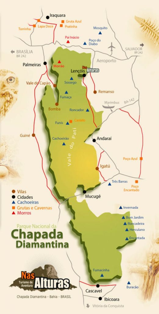
The park has a total area of 1520km², with more than half on Serra do Sincorá, surrounded by the main cities and villages of the region: Lençóis, Andaraí, Mucugê, Palmeiras, Vale do Capão and Igatu.